IMAGES TAKEN NEAR TO
Station Road, WESTERHAM, TN16 1NS
Introduction
This page details the photographs taken nearby to Station Road, TN16 1NS by members of the Geograph project.
The Geograph project started in 2005 with the aim of publishing, organising and preserving representative images for every square kilometre of Great Britain, Ireland and the Isle of Man.

There are currently over 7.5m images from over14,400 individuals and you can help contribute to the project by visiting https://www.geograph.org.uk
Image Map
Images are licensed for reuse under creativecommons.org/licenses/by-sa/2.0
Notes
- Clicking on the map will re-center to the selected point.
- The higher the marker number, the further away the image location is from the centre of the postcode.
Image Listing (62 Images Found)
Images are licensed for reuse under creativecommons.org/licenses/by-sa/2.0
Image
Details
Distance
1
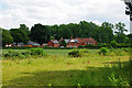
Houses, Station Road and Glebe Cottages, Brasted
Viewed from the field behind the churchyard.
Image: © Robin Webster
Taken: 24 Jul 2010
0.02 miles
2
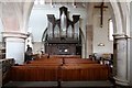
St Martin's Church, Brasted, Kent - Organ
Image: © John Salmon
Taken: 25 Mar 2009
0.09 miles
3
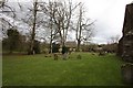
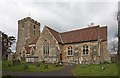
St Martin's Church, Brasted, Kent - Churchyard
Image: © John Salmon
Taken: 25 Mar 2009
0.09 miles
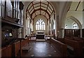
7
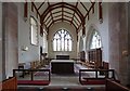
St Martin's Church, Brasted, Kent - Chancel
Image: © John Salmon
Taken: 25 Mar 2009
0.09 miles
8
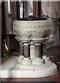
St Martin's Church, Brasted, Kent - Font
Image: © John Salmon
Taken: 25 Mar 2009
0.09 miles
9
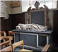
St Martin's Church, Brasted, Kent - Tomb chest
Image: © John Salmon
Taken: 25 Mar 2009
0.09 miles
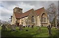
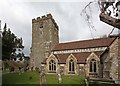
10
St Martin's Church, Brasted, Kent - East end
Image: © John Salmon
Taken: 25 Mar 2009
0.09 miles