IMAGES TAKEN NEAR TO
Brasted Chart, WESTERHAM, TN16 1LZ
Introduction
This page details the photographs taken nearby to TN16 1LZ by members of the Geograph project.
The Geograph project started in 2005 with the aim of publishing, organising and preserving representative images for every square kilometre of Great Britain, Ireland and the Isle of Man.

There are currently over 7.5m images from over14,400 individuals and you can help contribute to the project by visiting https://www.geograph.org.uk
Image Map (Loading...)


Getting Data...Please wait
Leaflet Map data © OpenStreetMap
Images are licensed for reuse under creativecommons.org/licenses/by-sa/2.0
Notes
- Clicking on the map will re-center to the selected point.
- The higher the marker number, the further away the image location is from the centre of the postcode.
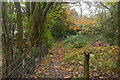
Image Listing (25 Images Found)
Images are licensed for reuse under creativecommons.org/licenses/by-sa/2.0
Image
Details
Distance
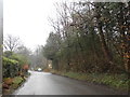
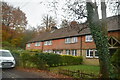
3
Road mirrors, Brasted Chart, Kent
Several of the large houses on the east side of Chart Lane have positioned mirrors opposite the exits from their drives, in order to be able to see properly if it is safe to drive their cars out onto the lane. Some three of these mirrors are to be seen in this photograph.
Image: © Dr Neil Clifton
Taken: 23 May 2006
0.04 miles
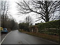
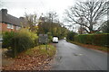
4
London Countryway in Kent (216)
The road at Brasted Chart is reached. To proceed to the next section of the London Countryway go to www.geograph.org.uk/geotrips/1270 .
Image: © Shazz
Taken: 1 Jul 2017
0.04 miles
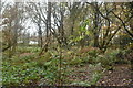
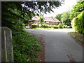
10
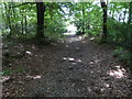
London Countryway in Kent (215)
This public footpath heads west towards a driveway.
Image: © Shazz
Taken: 1 Jul 2017
0.09 miles