IMAGES TAKEN NEAR TO
High Street, WESTERHAM, TN16 1HU
Introduction
This page details the photographs taken nearby to High Street, TN16 1HU by members of the Geograph project.
The Geograph project started in 2005 with the aim of publishing, organising and preserving representative images for every square kilometre of Great Britain, Ireland and the Isle of Man.

There are currently over 7.5m images from over14,400 individuals and you can help contribute to the project by visiting https://www.geograph.org.uk
Image Map (Loading...)


Getting Data...Please wait
Leaflet Map data © OpenStreetMap
Images are licensed for reuse under creativecommons.org/licenses/by-sa/2.0
Notes
- Clicking on the map will re-center to the selected point.
- The higher the marker number, the further away the image location is from the centre of the postcode.
Image Listing (72 Images Found)
Images are licensed for reuse under creativecommons.org/licenses/by-sa/2.0
Image
Details
Distance
1
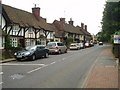
Brasted High Street on the A25
Picture taken from close to the village hall, this village was 'saved' by the building of the M25 nearby.
Image: © Nigel Freeman
Taken: 9 Jul 2005
0.02 miles
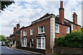
2
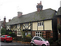
Houses on High Street
A mock tudor building with later side extension, split into three cottages.
Image: © Oast House Archive
Taken: 5 Nov 2010
0.02 miles
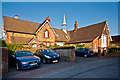
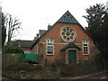
3
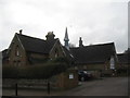
Brasted Old School
On the A25 Brasted High Street. Now converted into various houses.
Image: © David Anstiss
Taken: 13 Mar 2010
0.03 miles
4
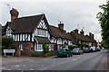
Alms Row Cottages
Row of cottages of various ages on the south side of High Street, all grade II listed. The nearest building is a mid 19th century addition to the row (see www.historicengland.org.uk/listing/the-list/list-entry/1085839), the next section is much earlier, dating from the 16th century or earlier (see www.historicengland.org.uk/listing/the-list/list-entry/1336437), the lower pair of buildings beyond also date from the 16th century or earlier (see www.historicengland.org.uk/listing/the-list/list-entry/1249449), and the final section is a former 16th century Wealden hall house (see www.historicengland.org.uk/listing/the-list/list-entry/1085840).
Image: © Ian Capper
Taken: 20 Jun 2013
0.03 miles
5
Holmesdale House
House on the south side of High Street.
The name Holmesdale refers to the line of Gault Clay that lies between the Chalk of the North Downs and the Greensand ridges, such as Leith Hill and Holmbury Hill to the west, Park Hill in Reigate, and Ide Hill and Toys Hill in Kent.
Image: © Ian Capper
Taken: 20 Jun 2013
0.03 miles
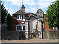
6
Former Brasted village school
Former school, now converted, the school having merged with that of neighbouring Sundridge.
Image: © Ian Capper
Taken: 28 Jun 2012
0.04 miles
7
Brasted War Memorial
Seen across the very busy A25 during a rare break in the traffic, this attractive war memorial is to the men of Brasted who died in the two World Wars.
Image: © Marathon
Taken: 19 Aug 2013
0.04 miles
8
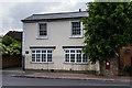
The Grey House
House on north side of High Street, next to the Village Hall.
Image: © Ian Capper
Taken: 20 Jun 2013
0.04 miles
9
Lindertis House
Converted church on the A25 Brasted High Street, opposite the Bull Inn.
Image: © David Anstiss
Taken: 13 Mar 2010
0.05 miles
10
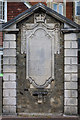
Brasted War Memorial
Village war memorial, made of Portland Stone inset with Ragstone, listing names of the local fallen from both the First and Second World Wars. For wider view see Image
Image: © Ian Capper
Taken: 20 Jun 2013
0.05 miles