IMAGES TAKEN NEAR TO
Cobs Close, SEVENOAKS, TN15 9DB
Introduction
This page details the photographs taken nearby to Cobs Close, TN15 9DB by members of the Geograph project.
The Geograph project started in 2005 with the aim of publishing, organising and preserving representative images for every square kilometre of Great Britain, Ireland and the Isle of Man.

There are currently over 7.5m images from over14,400 individuals and you can help contribute to the project by visiting https://www.geograph.org.uk
Image Map
Images are licensed for reuse under creativecommons.org/licenses/by-sa/2.0
Notes
- Clicking on the map will re-center to the selected point.
- The higher the marker number, the further away the image location is from the centre of the postcode.
Image Listing (61 Images Found)
Images are licensed for reuse under creativecommons.org/licenses/by-sa/2.0
Image
Details
Distance
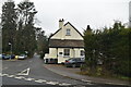
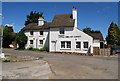
1

Formerly the Cob Tree, Ightham
This former pub is shown here as a private house. Later it became a day nursery.
Image: © Robin Webster
Taken: 6 Feb 2007
0.05 miles
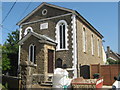
6
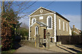
Wesleyan Chapel, Ightham
Built in 1848.
Image: © Robin Webster
Taken: 6 Feb 2007
0.07 miles
7
Converted Wesleyan Chapel
This chapel on Chapel Row, Ightham has been converted into a house. It is now called 'Wesleyan Place'.
Image: © David Anstiss
Taken: 24 May 2009
0.07 miles