IMAGES TAKEN NEAR TO
Tonbridge Road, SEVENOAKS, TN15 9AN
Introduction
This page details the photographs taken nearby to Tonbridge Road, TN15 9AN by members of the Geograph project.
The Geograph project started in 2005 with the aim of publishing, organising and preserving representative images for every square kilometre of Great Britain, Ireland and the Isle of Man.

There are currently over 7.5m images from over14,400 individuals and you can help contribute to the project by visiting https://www.geograph.org.uk
Image Map
Images are licensed for reuse under creativecommons.org/licenses/by-sa/2.0
Notes
- Clicking on the map will re-center to the selected point.
- The higher the marker number, the further away the image location is from the centre of the postcode.
Image Listing (30 Images Found)
Images are licensed for reuse under creativecommons.org/licenses/by-sa/2.0
Image
Details
Distance
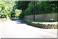
2
Ightham Kent
The bus stop says this is Ightham Park. The main road is the A227 Tonbridge Rd the minor road to the left is
Image
Image: © Glyn Baker
Taken: 20 Mar 2008
0.11 miles
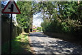
3
Large cottage near Ightham
A very typical cottage of this area.
Image: © N Chadwick
Taken: 22 Jun 2008
0.13 miles
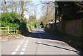
6
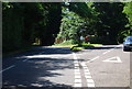
Road junction with the A227, near Ightham
Image: © N Chadwick
Taken: 22 Jun 2008
0.16 miles
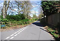
9
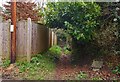
Ightham Footpath
A short footpath between Image and the A227 Tonbridge Rd
Image: © Glyn Baker
Taken: 20 Mar 2008
0.18 miles