IMAGES TAKEN NEAR TO
Abbott Road, SEVENOAKS, TN15 8SB
Introduction
This page details the photographs taken nearby to Abbott Road, TN15 8SB by members of the Geograph project.
The Geograph project started in 2005 with the aim of publishing, organising and preserving representative images for every square kilometre of Great Britain, Ireland and the Isle of Man.

There are currently over 7.5m images from over14,400 individuals and you can help contribute to the project by visiting https://www.geograph.org.uk
Image Map
Images are licensed for reuse under creativecommons.org/licenses/by-sa/2.0
Notes
- Clicking on the map will re-center to the selected point.
- The higher the marker number, the further away the image location is from the centre of the postcode.
Image Listing (64 Images Found)
Images are licensed for reuse under creativecommons.org/licenses/by-sa/2.0
Image
Details
Distance
1
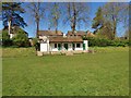
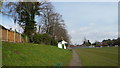
Football Pavilion in the Park
This is the Football Pavilion in Borough Green Recreation Ground as viewed from the middle of the football pitch.
Image: © John P Reeves
Taken: 19 Apr 2020
0.06 miles
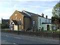
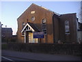
3
Borough Green Baptist Church
On junction of A227 Maidstone Road (in front) and High Street (behind church).
Image: © David Anstiss
Taken: 2 Mar 2009
0.08 miles
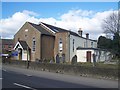
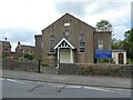
5
Borough Green Baptist Church, Maidstone Road
Image: © David Howard
Taken: 26 Mar 2012
0.08 miles
7
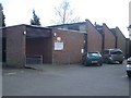
Borough Green Library
In town carpark off High Street, beside village hall.
Image: © David Anstiss
Taken: 2 Mar 2009
0.08 miles
8
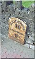
Old Mileplate by the A25, Maidstone Road, Borough Green
Metal plate attached to stone wall by the A25, in parish of WROTHAM (TONBRIDGE AND MALLING District), Maidstone Road, Brough Green, by church, in stone boundary wall of church, beside traffic lights, on North side of road. Wrotham iron plate, erected by the Wrotham Heath turnpike trust in the 19th century.
Inscription reads:-
MAIDSTONE
10
GODSTONE
18½
Kent HER.
HER Number: TQ 65 NW 267 https://www.heritagegateway.org.uk/Gateway/Results_Single.aspx?uid=MKE78079&resourceID=1005
Milestone Society National ID: KE_MDGS10.
Image: © C Woodward
Taken: 15 May 2007
0.08 miles
9
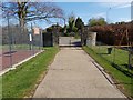
Entrance to the Recreation Ground
This is the entrance gateway to the Borough Green Recreation Ground as viewed from the inside looking out towards the A25.
Image: © John P Reeves
Taken: 19 Apr 2020
0.09 miles