IMAGES TAKEN NEAR TO
Staleys Road, SEVENOAKS, TN15 8RR
Introduction
This page details the photographs taken nearby to Staleys Road, TN15 8RR by members of the Geograph project.
The Geograph project started in 2005 with the aim of publishing, organising and preserving representative images for every square kilometre of Great Britain, Ireland and the Isle of Man.

There are currently over 7.5m images from over14,400 individuals and you can help contribute to the project by visiting https://www.geograph.org.uk
Image Map
Images are licensed for reuse under creativecommons.org/licenses/by-sa/2.0
Notes
- Clicking on the map will re-center to the selected point.
- The higher the marker number, the further away the image location is from the centre of the postcode.
Image Listing (39 Images Found)
Images are licensed for reuse under creativecommons.org/licenses/by-sa/2.0
Image
Details
Distance
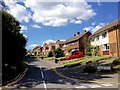
4
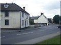
The Red Lion Public House, Borough Green
Closed pub, on bend on A25 Sevenoaks Road, opposite Western Road.
Image: © David Anstiss
Taken: 2 Mar 2009
0.10 miles
6
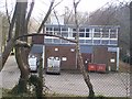
Borough Green Telephone Exchange
BT Managed. On access road to Brasted House.
Image: © David Anstiss
Taken: 2 Mar 2009
0.12 miles
7
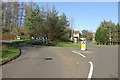
Roundabout, Borough Green
Looking north.
Image: © Robin Webster
Taken: 3 Feb 2007
0.14 miles
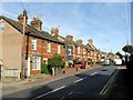
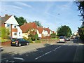
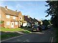
10
Houses on Maidstone Road, Borough Green
Image: © David Howard
Taken: 26 Mar 2012
0.15 miles