IMAGES TAKEN NEAR TO
Long Mill Lane, SEVENOAKS, TN15 8QG
Introduction
This page details the photographs taken nearby to Long Mill Lane, TN15 8QG by members of the Geograph project.
The Geograph project started in 2005 with the aim of publishing, organising and preserving representative images for every square kilometre of Great Britain, Ireland and the Isle of Man.

There are currently over 7.5m images from over14,400 individuals and you can help contribute to the project by visiting https://www.geograph.org.uk
Image Map
Images are licensed for reuse under creativecommons.org/licenses/by-sa/2.0
Notes
- Clicking on the map will re-center to the selected point.
- The higher the marker number, the further away the image location is from the centre of the postcode.
Image Listing (37 Images Found)
Images are licensed for reuse under creativecommons.org/licenses/by-sa/2.0
Image
Details
Distance
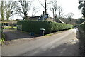
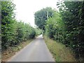
2
Napps Farm
On access road to Birchin Napps Farm. The Wealdway (long distance path) from Shipbourne Forest to Platts Wood passes this farm.
Image: © David Anstiss
Taken: 2 Mar 2009
0.02 miles
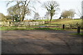
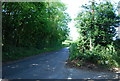
4
Wealdway goes to Shipbourne Forest
The long distance path leaves Birchin Napps access road and heads along byway into forest.
Image: © David Anstiss
Taken: 2 Mar 2009
0.05 miles

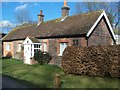
8
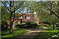
Beechin Oast, Long Mill Lane, Platt, Kent
Image: © Oast House Archive
Taken: 22 Apr 2009
0.09 miles

