IMAGES TAKEN NEAR TO
Bone Ashe Lane, SEVENOAKS, TN15 8NW
Introduction
This page details the photographs taken nearby to Bone Ashe Lane, TN15 8NW by members of the Geograph project.
The Geograph project started in 2005 with the aim of publishing, organising and preserving representative images for every square kilometre of Great Britain, Ireland and the Isle of Man.

There are currently over 7.5m images from over14,400 individuals and you can help contribute to the project by visiting https://www.geograph.org.uk
Image Map
Images are licensed for reuse under creativecommons.org/licenses/by-sa/2.0
Notes
- Clicking on the map will re-center to the selected point.
- The higher the marker number, the further away the image location is from the centre of the postcode.
Image Listing (60 Images Found)
Images are licensed for reuse under creativecommons.org/licenses/by-sa/2.0
Image
Details
Distance
2
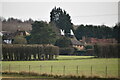
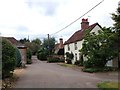
Boneashe Lane, Platt, Kent
from where it meets Comp Lane.
Image: © Rodney Burton
Taken: 9 Sep 2006
0.03 miles
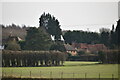
4
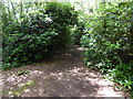
London Countryway in Kent (108)
The footpath heads through the woods towards Platt.
Image: © Shazz
Taken: 14 Jul 2016
0.15 miles
6
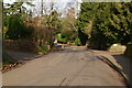
London Countryway in Kent (110)
The journey leaves Long Mill Lane by the bridleway seen here.
Image: © Shazz
Taken: 14 Jul 2016
0.18 miles
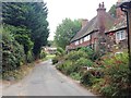
7
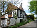
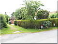
Cottage and converted oast houses, Platt
This is Platt Oast, a delightful cottage with three attached converted oast houses, although only one is visible in the photograph. It is at the southern end of the village of Platt in Long Mill Lane.
Image: © Marathon
Taken: 11 May 2012
0.18 miles
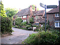
8
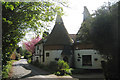
Platt Oast, Long Mill Lane, Platt, Kent
Image: © Oast House Archive
Taken: 22 Apr 2009
0.18 miles