IMAGES TAKEN NEAR TO
Maidstone Road, SEVENOAKS, TN15 8JS
Introduction
This page details the photographs taken nearby to Maidstone Road, TN15 8JS by members of the Geograph project.
The Geograph project started in 2005 with the aim of publishing, organising and preserving representative images for every square kilometre of Great Britain, Ireland and the Isle of Man.

There are currently over 7.5m images from over14,400 individuals and you can help contribute to the project by visiting https://www.geograph.org.uk
Image Map
Images are licensed for reuse under creativecommons.org/licenses/by-sa/2.0
Notes
- Clicking on the map will re-center to the selected point.
- The higher the marker number, the further away the image location is from the centre of the postcode.
Image Listing (5 Images Found)
Images are licensed for reuse under creativecommons.org/licenses/by-sa/2.0
Image
Details
Distance
2
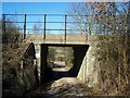
Railway bridge over cottage access road
Access road also a footpath from A25 Maidstone Road to Windmill Hill road.
Railway heads left to Borough Green from West Malling.
Image: © David Anstiss
Taken: 2 Mar 2009
0.18 miles
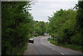
5
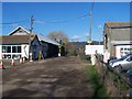
Nepicar Farm
On access road of A25 Maidstone Road.
This working farm is also open to visitors, such as school trips and families, it also has a cafe and farmshop for other visitors.
Image: © David Anstiss
Taken: 2 Mar 2009
0.23 miles