IMAGES TAKEN NEAR TO
Maidstone Road, SEVENOAKS, TN15 8JR
Introduction
This page details the photographs taken nearby to Maidstone Road, TN15 8JR by members of the Geograph project.
The Geograph project started in 2005 with the aim of publishing, organising and preserving representative images for every square kilometre of Great Britain, Ireland and the Isle of Man.

There are currently over 7.5m images from over14,400 individuals and you can help contribute to the project by visiting https://www.geograph.org.uk
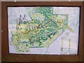
Image Map
Images are licensed for reuse under creativecommons.org/licenses/by-sa/2.0
Notes
- Clicking on the map will re-center to the selected point.
- The higher the marker number, the further away the image location is from the centre of the postcode.
Image Listing (9 Images Found)
Images are licensed for reuse under creativecommons.org/licenses/by-sa/2.0
Image
Details
Distance
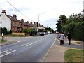
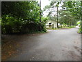
2
Junction of Grange Road and Maidstone Road, Platt
Overlooking the Platt industrial estate
Image: © David Howard
Taken: 26 Mar 2012
0.17 miles
3
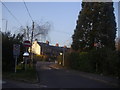
Grange Road, Platt
The one way fork, looking towards the A25 Maidstone Road
Image: © David Howard
Taken: 26 Mar 2012
0.18 miles
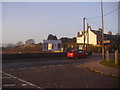
4
Junction of Grange Road and Maidstone Road, Platt
Looking across to the Platt industrial estate.
Image: © David Howard
Taken: 26 Mar 2012
0.19 miles

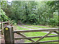
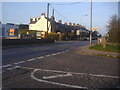
8
Vandalised sign in Platt Woods
Interesting wood close to the Wealdway, has groves of specific trees.
Image: © David Anstiss
Taken: 2 Mar 2009
0.22 miles
9
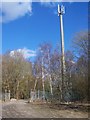
O2 Mobile Phone Mast
In Rugby Portland Cement Quarry works in Platt Industrial Estate. As seen from footpath from A25 Maidstone Road to A227 Wrotham Road.
Image: © David Anstiss
Taken: 2 Mar 2009
0.24 miles