IMAGES TAKEN NEAR TO
Annetts Hall, SEVENOAKS, TN15 8DY
Introduction
This page details the photographs taken nearby to Annetts Hall, TN15 8DY by members of the Geograph project.
The Geograph project started in 2005 with the aim of publishing, organising and preserving representative images for every square kilometre of Great Britain, Ireland and the Isle of Man.

There are currently over 7.5m images from over14,400 individuals and you can help contribute to the project by visiting https://www.geograph.org.uk
Image Map
Images are licensed for reuse under creativecommons.org/licenses/by-sa/2.0
Notes
- Clicking on the map will re-center to the selected point.
- The higher the marker number, the further away the image location is from the centre of the postcode.
Image Listing (36 Images Found)
Images are licensed for reuse under creativecommons.org/licenses/by-sa/2.0
Image
Details
Distance
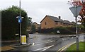
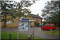

10
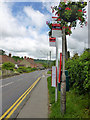
The Avenue bus stop, Wrotham Road
I thought at first here was a record closeness of successive bus stops, but no, this is the same stop, code KNTJPGAP, for some reason in duplicate. Was it because of the hanging flower baskets?
Image: © Robin Webster
Taken: 4 Jun 2012
0.21 miles