IMAGES TAKEN NEAR TO
Fairfield Road, SEVENOAKS, TN15 8DP
Introduction
This page details the photographs taken nearby to Fairfield Road, TN15 8DP by members of the Geograph project.
The Geograph project started in 2005 with the aim of publishing, organising and preserving representative images for every square kilometre of Great Britain, Ireland and the Isle of Man.

There are currently over 7.5m images from over14,400 individuals and you can help contribute to the project by visiting https://www.geograph.org.uk
Image Map
Images are licensed for reuse under creativecommons.org/licenses/by-sa/2.0
Notes
- Clicking on the map will re-center to the selected point.
- The higher the marker number, the further away the image location is from the centre of the postcode.
Image Listing (60 Images Found)
Images are licensed for reuse under creativecommons.org/licenses/by-sa/2.0
Image
Details
Distance
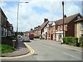
1
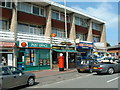
Borough Green Shops
Shopping arcade with Post Office at Borough Green, A227, just west of the station.
Image: © Chris Shaw
Taken: 18 Jun 2005
0.09 miles
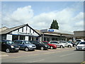
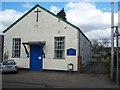
2
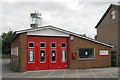
Borough Green fire station
Borough Green fire station, Western Road, Borough Green, Kent
Image: © Kevin Hale
Taken: 17 Jun 2007
0.10 miles
9
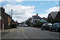
St Joseph's Chapel
On Western Road, Borough Green. The church was originally a Badminton Hall in 1927.
Image: © David Anstiss
Taken: 2 Mar 2009
0.15 miles
10
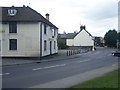
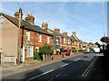
The Red Lion Public House, Borough Green
Closed pub, on bend on A25 Sevenoaks Road, opposite Western Road.
Image: © David Anstiss
Taken: 2 Mar 2009
0.15 miles