IMAGES TAKEN NEAR TO
Windmill Hill, SEVENOAKS, TN15 7SX
Introduction
This page details the photographs taken nearby to Windmill Hill, TN15 7SX by members of the Geograph project.
The Geograph project started in 2005 with the aim of publishing, organising and preserving representative images for every square kilometre of Great Britain, Ireland and the Isle of Man.

There are currently over 7.5m images from over14,400 individuals and you can help contribute to the project by visiting https://www.geograph.org.uk
Image Map
Images are licensed for reuse under creativecommons.org/licenses/by-sa/2.0
Notes
- Clicking on the map will re-center to the selected point.
- The higher the marker number, the further away the image location is from the centre of the postcode.
Image Listing (5 Images Found)
Images are licensed for reuse under creativecommons.org/licenses/by-sa/2.0
Image
Details
Distance
1
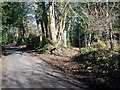
Wealdway leaves Windmill Hill road
The long distance path heads right to Platt via path through large gardens of various houses.
Image: © David Anstiss
Taken: 2 Mar 2009
0.02 miles
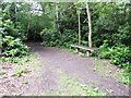
2
London Countryway in Kent (106)
The enclosed path has kept me safe from getting lost but not from brambles, nettles and so forth. The house ahead means I shall soon reach the road. Good.
Image: © Shazz
Taken: 14 Jul 2016
0.05 miles
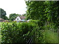
3
London Countryway in Kent (107)
This bench on the London Countryway is also on the Wealdway. Very soon these long distance paths diverge, never to meet again.
Image: © Shazz
Taken: 14 Jul 2016
0.07 miles
4
Foot path through Valley Woods
Linking Windmill Lane to Wrotham Heath.
Image: © Anthony Vosper
Taken: 21 Sep 2020
0.08 miles
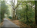
5
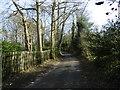
Windmill Hill
This is just south of the A25 and leads to Great Comp garden or the village of Platt.
Image: © Marathon
Taken: 10 Apr 2016
0.19 miles