IMAGES TAKEN NEAR TO
Maidstone Road, SEVENOAKS, TN15 7SW
Introduction
This page details the photographs taken nearby to Maidstone Road, TN15 7SW by members of the Geograph project.
The Geograph project started in 2005 with the aim of publishing, organising and preserving representative images for every square kilometre of Great Britain, Ireland and the Isle of Man.

There are currently over 7.5m images from over14,400 individuals and you can help contribute to the project by visiting https://www.geograph.org.uk
Image Map
Images are licensed for reuse under creativecommons.org/licenses/by-sa/2.0
Notes
- Clicking on the map will re-center to the selected point.
- The higher the marker number, the further away the image location is from the centre of the postcode.
Image Listing (18 Images Found)
Images are licensed for reuse under creativecommons.org/licenses/by-sa/2.0
Image
Details
Distance
1
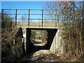
Railway bridge over cottage access road
Access road also a footpath from A25 Maidstone Road to Windmill Hill road.
Railway heads left to Borough Green from West Malling.
Image: © David Anstiss
Taken: 2 Mar 2009
0.03 miles
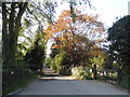
9
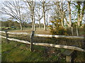
Stile alongside Windmill Hill
Although there is no footpath marked on the map from this stile, Windmill Hill is quite narrow here and I assume the path just provides a safer alternative to the road.
Image: © Marathon
Taken: 10 Apr 2016
0.16 miles
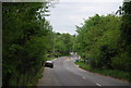
10
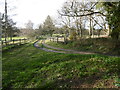
Track off Windmill Hill
Although there is no footpath marked on the map from the stile on the right, Windmill Hill is quite narrow here and I assume the path just provides a safer alternative to the road. The track ahead leads to Gallows Hill.
Image: © Marathon
Taken: 10 Apr 2016
0.16 miles