IMAGES TAKEN NEAR TO
London Road, SEVENOAKS, TN15 7RJ
Introduction
This page details the photographs taken nearby to London Road, TN15 7RJ by members of the Geograph project.
The Geograph project started in 2005 with the aim of publishing, organising and preserving representative images for every square kilometre of Great Britain, Ireland and the Isle of Man.

There are currently over 7.5m images from over14,400 individuals and you can help contribute to the project by visiting https://www.geograph.org.uk
Image Map
Images are licensed for reuse under creativecommons.org/licenses/by-sa/2.0
Notes
- Clicking on the map will re-center to the selected point.
- The higher the marker number, the further away the image location is from the centre of the postcode.
Image Listing (24 Images Found)
Images are licensed for reuse under creativecommons.org/licenses/by-sa/2.0
Image
Details
Distance
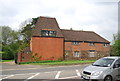
4
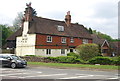
The Moat
Grade II listed. http://www.britishlistedbuildings.co.uk/en-427472-moat-restaurant-wrotham-kent
Image: © N Chadwick
Taken: 18 May 2013
0.08 miles
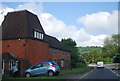
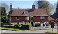
5
The Moat
Grade II listed. http://www.britishlistedbuildings.co.uk/en-427472-moat-restaurant-wrotham-kent
Image: © N Chadwick
Taken: 18 May 2013
0.09 miles
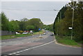
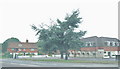
7
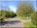
Nepicar Lane, Wrotham Heath
The bridge ahead carries the M20 motorway.
Image: © Chris Whippet
Taken: 6 May 2016
0.10 miles
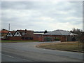
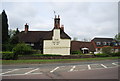
8
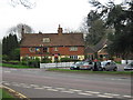
The Moat Public House, Wrotham
Public house on A20 London Road, opposite Gasoline Alley.
Image: © David Anstiss
Taken: 15 Apr 2009
0.11 miles