IMAGES TAKEN NEAR TO
Ridgy Field Close, SEVENOAKS, TN15 7QZ
Introduction
This page details the photographs taken nearby to Ridgy Field Close, TN15 7QZ by members of the Geograph project.
The Geograph project started in 2005 with the aim of publishing, organising and preserving representative images for every square kilometre of Great Britain, Ireland and the Isle of Man.

There are currently over 7.5m images from over14,400 individuals and you can help contribute to the project by visiting https://www.geograph.org.uk
Image Map
Images are licensed for reuse under creativecommons.org/licenses/by-sa/2.0
Notes
- Clicking on the map will re-center to the selected point.
- The higher the marker number, the further away the image location is from the centre of the postcode.
Image Listing (183 Images Found)
Images are licensed for reuse under creativecommons.org/licenses/by-sa/2.0
Image
Details
Distance
10
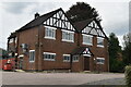
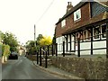
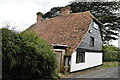
Houses at the southern approach to Wrotham
Stone Cottage here guards the entrance to St Mary's Road as it leads off Borough Green Road.
Image: © Marathon
Taken: 8 Jun 2013
0.08 miles