IMAGES TAKEN NEAR TO
Parsons Lane, SEVENOAKS, TN15 7PW
Introduction
This page details the photographs taken nearby to Parsons Lane, TN15 7PW by members of the Geograph project.
The Geograph project started in 2005 with the aim of publishing, organising and preserving representative images for every square kilometre of Great Britain, Ireland and the Isle of Man.

There are currently over 7.5m images from over14,400 individuals and you can help contribute to the project by visiting https://www.geograph.org.uk
Image Map
Images are licensed for reuse under creativecommons.org/licenses/by-sa/2.0
Notes
- Clicking on the map will re-center to the selected point.
- The higher the marker number, the further away the image location is from the centre of the postcode.
Image Listing (15 Images Found)
Images are licensed for reuse under creativecommons.org/licenses/by-sa/2.0
Image
Details
Distance
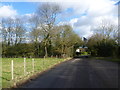
1
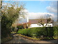
Parsons Lane, Stansted
The Old Rectory is down this lane, hence the name, presumably. The property in the picture is called the Old Farmhouse.
Image: © Stephen Craven
Taken: 26 Dec 2008
0.04 miles
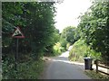
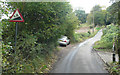
3
Closed Bridal Way
On Hatham Green Lane, near Stansted. This bridleway is closed for 6 months from 26th March 2009 because of pipelaying works between Farningham and Hadlow.
Note: Murphy Pipelines Ltd are contractors and they cannot spell 'bridleway'.
Image: © David Anstiss
Taken: 15 Apr 2009
0.07 miles
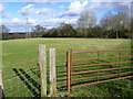
4
Plaxdale Green Road near Stansted
This is Plaxdale Green Road on the outskirts of the scattered village of Stansted.
Image: © Marathon
Taken: 5 Feb 2013
0.09 miles
5
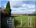
View from Plaxdale Green Road
This is on the outskirts of the scattered village of Stansted. A footpath runs along the left hand side of this field on its way to Hatham Green Lane.
Image: © Marathon
Taken: 5 Feb 2013
0.10 miles
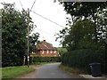
6
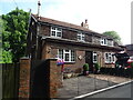
Old Post Office, Stansted
Showing position of Postbox No. TN15 235.
See Image] for postbox
Image: © JThomas
Taken: 21 Jun 2022
0.10 miles
7
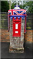
Edward VII postbox, Old Post Office, Stansted
Postbox No. DA15 235.
See Image for context.
Image: © JThomas
Taken: 21 Jun 2022
0.11 miles
8
Footpath near Hollands Farm
This is the view from Plaxdale Green Road on the outskirts of the scattered village of Stansted. A footpath runs along the left hand side of this field on its way to Hatham Green Lane.
Image: © Marathon
Taken: 5 Feb 2013
0.11 miles
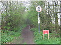
9
Hatham Green Lane - Steep Hill 1:6
Hatham Green Lane, Stansted. 1:6 steep hill up sign.
Image: © Adam Morse
Taken: 10 Oct 2009
0.13 miles