IMAGES TAKEN NEAR TO
Tumblefield Road, SEVENOAKS, TN15 7PR
Introduction
This page details the photographs taken nearby to Tumblefield Road, TN15 7PR by members of the Geograph project.
The Geograph project started in 2005 with the aim of publishing, organising and preserving representative images for every square kilometre of Great Britain, Ireland and the Isle of Man.

There are currently over 7.5m images from over14,400 individuals and you can help contribute to the project by visiting https://www.geograph.org.uk
Image Map
Images are licensed for reuse under creativecommons.org/licenses/by-sa/2.0
Notes
- Clicking on the map will re-center to the selected point.
- The higher the marker number, the further away the image location is from the centre of the postcode.
Image Listing (59 Images Found)
Images are licensed for reuse under creativecommons.org/licenses/by-sa/2.0
Image
Details
Distance
1
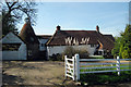
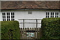
Stansted Lodge Farm, Stansted, Kent
Image: © Oast House Archive
Taken: 22 Apr 2009
0.01 miles
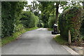
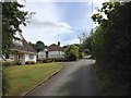
6
Tumblefield Road
Heading south from Stansted.
Image: © JThomas
Taken: 21 Jun 2022
0.06 miles
9
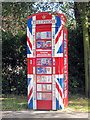
Stansted Information Box
A converted K6 telephone box painted in the Union flag colours and each window pane decorated with a child's drawing.
Image: © Oast House Archive
Taken: 8 Sep 2012
0.12 miles