IMAGES TAKEN NEAR TO
Harvel Road, SEVENOAKS, TN15 7JT
Introduction
This page details the photographs taken nearby to Harvel Road, TN15 7JT by members of the Geograph project.
The Geograph project started in 2005 with the aim of publishing, organising and preserving representative images for every square kilometre of Great Britain, Ireland and the Isle of Man.

There are currently over 7.5m images from over14,400 individuals and you can help contribute to the project by visiting https://www.geograph.org.uk
Image Map
Images are licensed for reuse under creativecommons.org/licenses/by-sa/2.0
Notes
- Clicking on the map will re-center to the selected point.
- The higher the marker number, the further away the image location is from the centre of the postcode.
Image Listing (75 Images Found)
Images are licensed for reuse under creativecommons.org/licenses/by-sa/2.0
Image
Details
Distance

4
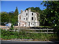
Derelict house at Vigo
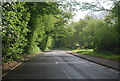
This, doubtlessly once imposing, house stands in the point where Harvel Road and the main A227 Gravesend Road meet. Although it looks derelict and empty and part of it has been lost, the building work going on hopefully implies it is to be restored.
Image: © Marathon
Taken: 13 Sep 2011
0.05 miles
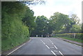
5
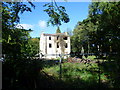
Derelict house near Vigo
This, doubtlessly once imposing, house stands in the point where Harvel Road and the main A227 Gravesend Road meet. Although it looks derelict and empty and part of it has been lost, the building work going on hopefully implies it is to be restored.
Image: © Marathon
Taken: 13 Sep 2011
0.05 miles
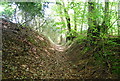
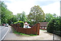
8
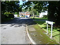
The Covert, Vigo
The village of Vigo takes its name from the Vigo Inn, to the west on the main A227. The inn dates from 1471 and is reputed to have been renamed by a local man after he purchased it with prize money from his time under Admiral Rooke at the Battle of Vigo Bay during the Franco Spanish War in 1702.
At the outbreak of the Second World War and the subsequent increase in size of the army, the need for large numbers of suitable candidates to train as officers soon became apparent. Wrotham Camp was built on what is now the site of Vigo Village to train those officers. It was the largest Officer Cadet Training Unit in the world. With the departure of the army in 1946 ‘squatters’ moved in. These were people who, for the most part, had lost everything they had during the blitz. Here they found ready made accommodation in the form of Nissen Huts well made roads and a community soon formed. The presence of some 1,000 people in the area prompted the local councils to improve conditions for the inhabitants, although at a price as they could now charge rent. By the late 1950s, many of the residents were re-housed in nearby areas and the land was partly cleared. The land was then sold for property development and Vigo Village came into being. Immediately to the south is Trosley Country Park.
This view is of The Covert, just off Waterlow Road and close to the entrance to Trosley Country Park.
Image: © Marathon
Taken: 13 Sep 2011
0.07 miles