IMAGES TAKEN NEAR TO
Crowhurst Lane, SEVENOAKS, TN15 7HH
Introduction
This page details the photographs taken nearby to Crowhurst Lane, TN15 7HH by members of the Geograph project.
The Geograph project started in 2005 with the aim of publishing, organising and preserving representative images for every square kilometre of Great Britain, Ireland and the Isle of Man.

There are currently over 7.5m images from over14,400 individuals and you can help contribute to the project by visiting https://www.geograph.org.uk
Image Map
Images are licensed for reuse under creativecommons.org/licenses/by-sa/2.0
Notes
- Clicking on the map will re-center to the selected point.
- The higher the marker number, the further away the image location is from the centre of the postcode.
Image Listing (15 Images Found)
Images are licensed for reuse under creativecommons.org/licenses/by-sa/2.0
Image
Details
Distance
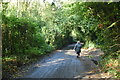
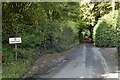
4
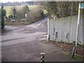
Footpath ends at crossroads
Footpath from Manor Lane,New Ash Green stops here. On left is Billet Hill road, also going left uphill is Crowhurst Lane. On right, going uphill is Rogers Wood Road and also going right is Fawkham Green Road.
Image: © David Anstiss
Taken: 20 Feb 2009
0.04 miles
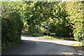
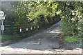
6
Crossroads, Ash
The village, right, straight on Fawkham Green, left Farningham, behind the camera, West Kingsdown.
Image: © Robin Webster
Taken: 28 Jan 2007
0.05 miles
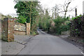
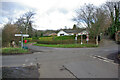
9
Entrance to Saxten's Wood and Cages Wood
On Roger Wood Lane. The wood is managed by the Woodland Trust. It has various paths through the wood for public access.
Image: © David Anstiss
Taken: 20 Feb 2009
0.08 miles