IMAGES TAKEN NEAR TO
Butchers Lane, SEVENOAKS, TN15 7HF
Introduction
This page details the photographs taken nearby to Butchers Lane, TN15 7HF by members of the Geograph project.
The Geograph project started in 2005 with the aim of publishing, organising and preserving representative images for every square kilometre of Great Britain, Ireland and the Isle of Man.

There are currently over 7.5m images from over14,400 individuals and you can help contribute to the project by visiting https://www.geograph.org.uk
Image Map
Images are licensed for reuse under creativecommons.org/licenses/by-sa/2.0
Notes
- Clicking on the map will re-center to the selected point.
- The higher the marker number, the further away the image location is from the centre of the postcode.
Image Listing (24 Images Found)
Images are licensed for reuse under creativecommons.org/licenses/by-sa/2.0
Image
Details
Distance
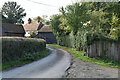
2
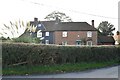
Johnson's Farmhouse
Grade II listed. https://historicengland.org.uk/listing/the-list/list-entry/1235103
Image: © N Chadwick
Taken: 22 Oct 2019
0.02 miles
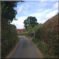
3
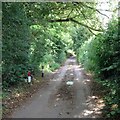
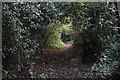
Footpath on Butchers Lane
Leads through Redlibbets Golf Course to Manor Lane. On right is carpark for 'Go Bananas', a children's activity centre.
Image: © David Anstiss
Taken: 20 Feb 2009
0.03 miles
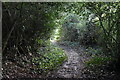
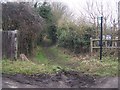
9
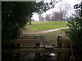
Stile into Redlibbets Golf Course
On footpath from Butchers Lane through golf course to Manor Lane.
Image: © David Anstiss
Taken: 20 Feb 2009
0.12 miles