IMAGES TAKEN NEAR TO
Ash Lane, SEVENOAKS, TN15 7EG
Introduction
This page details the photographs taken nearby to Ash Lane, TN15 7EG by members of the Geograph project.
The Geograph project started in 2005 with the aim of publishing, organising and preserving representative images for every square kilometre of Great Britain, Ireland and the Isle of Man.

There are currently over 7.5m images from over14,400 individuals and you can help contribute to the project by visiting https://www.geograph.org.uk
Image Map
Images are licensed for reuse under creativecommons.org/licenses/by-sa/2.0
Notes
- Clicking on the map will re-center to the selected point.
- The higher the marker number, the further away the image location is from the centre of the postcode.
Image Listing (5 Images Found)
Images are licensed for reuse under creativecommons.org/licenses/by-sa/2.0
Image
Details
Distance
4
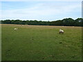
Sheep grazing near Plaxdale Green
West of Ash Lane.
Image: © JThomas
Taken: 21 Jun 2022
0.14 miles
5
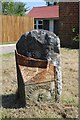
Old Milepost by the A20, London Road, Stansted
Cast iron post by the A20, in parish of Ash cum Ridley (Sevenoaks District), London Road, by Holly Lodge, West of Ash Lane, on open grass verge, in front of older milestone, on North-east side of road. Kent hipped iron plate, erected by the Wrotham & Maidstone Turnpike Trust in the 19th century.
Inscription reads:-
: WROTHAM / 2 : : ASH : : FARNINGHAM / 5 :
Scheduled Monument. List Entry Number: 1004196
https://historicengland.org.uk/listing/the-list/list-entry/1004196
Milestone Society National ID: KE_LF22.
Image: © Milestone Society
Taken: 18 May 2018
0.14 miles