IMAGES TAKEN NEAR TO
Granary Place, SEVENOAKS, TN15 7DZ
Introduction
This page details the photographs taken nearby to Granary Place, TN15 7DZ by members of the Geograph project.
The Geograph project started in 2005 with the aim of publishing, organising and preserving representative images for every square kilometre of Great Britain, Ireland and the Isle of Man.

There are currently over 7.5m images from over14,400 individuals and you can help contribute to the project by visiting https://www.geograph.org.uk
Image Map
Images are licensed for reuse under creativecommons.org/licenses/by-sa/2.0
Notes
- Clicking on the map will re-center to the selected point.
- The higher the marker number, the further away the image location is from the centre of the postcode.
Image Listing (11 Images Found)
Images are licensed for reuse under creativecommons.org/licenses/by-sa/2.0
Image
Details
Distance
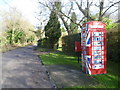
2
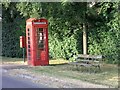
Rural telephone kiosk
With the advent of mobile phones, this scene will become incresingly infrequent over the coming years. Rural kisoks such as this used to provide an essential communications link for small villages in the countryside.
Image: © Hywel Williams
Taken: 29 Jun 2005
0.04 miles
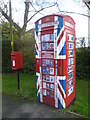
3
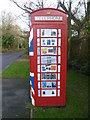
Telephone kiosk on Plaxdale Green Road
The rural telephone kiosk seen at http://www.geograph.org.uk/photo/22602 has now been taken over, smartened up and turned into the Stansted Information Box. Information is on all the sides as well as inside.
Another example of a phone box being given a new use - this time as a book exchange can be seen at http://www.geograph.org.uk/photo/3607771
Image: © Marathon
Taken: 5 Feb 2013
0.05 miles
4
Old telephone kiosk now put to a new use
The rural telephone kiosk on Plaxdale Green Road seen at http://www.geograph.org.uk/photo/22602 has now been taken over, smartened up and turned into the Stansted Information Box. Information is on all the sides as well as inside. For close ups see http://www.geograph.org.uk/photo/3321275 and http://www.geograph.org.uk/photo/3321280
Another example of a phone box being given a new use - this time as a book exchange can be seen at http://www.geograph.org.uk/photo/3607771
Image: © Marathon
Taken: 5 Feb 2013
0.05 miles
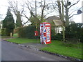
5
Stansted Information Box
The rural telephone kiosk seen at http://www.geograph.org.uk/photo/22602 has now been taken over, smartened up and turned into the Stansted Information Box. Information is on all the sides as well as inside. For close ups see http://www.geograph.org.uk/photo/3321275 and http://www.geograph.org.uk/photo/3321280
Another example of a phone box being given a new use - this time as a book exchange can be seen at http://www.geograph.org.uk/photo/3607771
Image: © Marathon
Taken: 5 Feb 2013
0.06 miles
6
A new use for an old telephone kiosk
The rural telephone kiosk seen at http://www.geograph.org.uk/photo/22602 has now been taken over, smartened up and turned into the Stansted Information Box. Information is on all the sides as well as inside.
Another example of a phone box being given a new use - this time as a book exchange can be seen at http://www.geograph.org.uk/photo/3607771
Image: © Marathon
Taken: 5 Feb 2013
0.06 miles
7
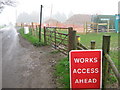
Closed footpath on Plaxdale Green Road
This footpath should lead across a field to A20 London Road. But due to the laying of a high-pressure gas pipe by Murphy Pipelines Ltd, it has been closed for safety reasons, until works completion in October 2009.
Image: © David Anstiss
Taken: 15 Apr 2009
0.15 miles
8
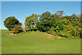
Field corner near Plaxdale Green Farm
It is a water trough to the left of the trees, not a stile.
Image: © Robin Webster
Taken: 24 Oct 2010
0.18 miles
9
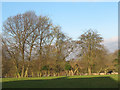
Sheep beyond the fence
A strip of pasture separates the field through which these sheep were ambling from the photographer's location on Plaxdale Green Road.
Image: © Stephen Craven
Taken: 26 Dec 2008
0.20 miles
10
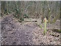
Footpath junction near Stansted Lodge Farm
Footpath from Plaxdale Green Road goes into woodland and then onto Tumblefield Road. Also a path heads left to Plaxdale Green Road,in Stansted from Labour-in-vain Road.
Image: © David Anstiss
Taken: 17 Feb 2009
0.23 miles