IMAGES TAKEN NEAR TO
High Street, SEVENOAKS, TN15 7AA
Introduction
This page details the photographs taken nearby to High Street, TN15 7AA by members of the Geograph project.
The Geograph project started in 2005 with the aim of publishing, organising and preserving representative images for every square kilometre of Great Britain, Ireland and the Isle of Man.

There are currently over 7.5m images from over14,400 individuals and you can help contribute to the project by visiting https://www.geograph.org.uk
Image Map
Images are licensed for reuse under creativecommons.org/licenses/by-sa/2.0
Notes
- Clicking on the map will re-center to the selected point.
- The higher the marker number, the further away the image location is from the centre of the postcode.
Image Listing (202 Images Found)
Images are licensed for reuse under creativecommons.org/licenses/by-sa/2.0
Image
Details
Distance
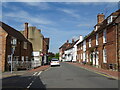
6
Rose & Crown
Sign for Image, a Shepherd Neame pub on High Street.
Image: © Oast House Archive
Taken: 9 Aug 2016
0.01 miles
7
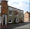
The Rose & Crown, Wrotham
On High Street.
See Image] for sign.
Image: © JThomas
Taken: 21 Jun 2022
0.01 miles
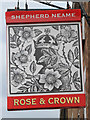
8
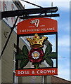
Sign for the Rose & Crown, Wrotham
See Image] for context.
Image: © JThomas
Taken: 21 Jun 2022
0.01 miles
9
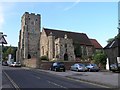
Wrotham Parish Church
The Parish Church of St. George, Wrotham
Image: © Hywel Williams
Taken: 29 Jun 2005
0.02 miles
10
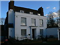
Bishop's Lodge, Wrotham
On the east side of the square, just south of the parish church.http://www.imagesofengland.org.uk/Details/Default.aspx?id=427586&mode=quick
Image: © Eirian Evans
Taken: 6 Feb 2008
0.02 miles