IMAGES TAKEN NEAR TO
Knatts Lane, SEVENOAKS, TN15 6YA
Introduction
This page details the photographs taken nearby to Knatts Lane, TN15 6YA by members of the Geograph project.
The Geograph project started in 2005 with the aim of publishing, organising and preserving representative images for every square kilometre of Great Britain, Ireland and the Isle of Man.

There are currently over 7.5m images from over14,400 individuals and you can help contribute to the project by visiting https://www.geograph.org.uk
Image Map
Images are licensed for reuse under creativecommons.org/licenses/by-sa/2.0
Notes
- Clicking on the map will re-center to the selected point.
- The higher the marker number, the further away the image location is from the centre of the postcode.
Image Listing (31 Images Found)
Images are licensed for reuse under creativecommons.org/licenses/by-sa/2.0
Image
Details
Distance
5
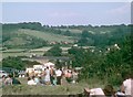
Knatts Valley
A Sidcup and District MCC grass hill climb event taking place in the foreground.
The large building at the bottom of the hill is visible in this photo: http://www.geograph.org.uk/photo/1706198
A 2010 view up the hill: http://www.geograph.org.uk/photo/1956575
Image: © G E Jeal
Taken: Unknown
0.14 miles
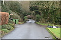
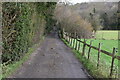
7

Looking along Knatts Valley Road
The Old Stables is just ahead on the right. Continuing along Knatts Valley Road brings you to the main part of Knatts Valley - the woodland in the distance on the side of the valley is the same woodland as seen at http://www.geograph.org.uk/photo/4059094
Image: © Marathon
Taken: 4 Jul 2014
0.14 miles
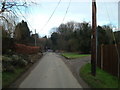
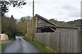
10
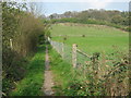
Bridleway to Stacklands Wood
This leads uphill from Knatts Lane and leads to School Lane, West Kingsdown. Wood on top of hill is Stacklands Wood.
Image: © David Anstiss
Taken: 15 Apr 2009
0.14 miles