IMAGES TAKEN NEAR TO
Magpie Bottom, SEVENOAKS, TN15 6XP
Introduction
This page details the photographs taken nearby to Magpie Bottom, TN15 6XP by members of the Geograph project.
The Geograph project started in 2005 with the aim of publishing, organising and preserving representative images for every square kilometre of Great Britain, Ireland and the Isle of Man.

There are currently over 7.5m images from over14,400 individuals and you can help contribute to the project by visiting https://www.geograph.org.uk
Image Map
Images are licensed for reuse under creativecommons.org/licenses/by-sa/2.0
Notes
- Clicking on the map will re-center to the selected point.
- The higher the marker number, the further away the image location is from the centre of the postcode.
Image Listing (45 Images Found)
Images are licensed for reuse under creativecommons.org/licenses/by-sa/2.0
Image
Details
Distance
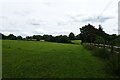
1
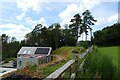
Construction of a new house
A house being constructed beside a path which runs between Romney Street Farm and Magpie Bottom.
Image: © DS Pugh
Taken: 27 Jun 2024
0.02 miles
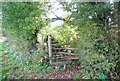
5
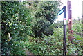
Path above Bell Cottage
The path runs between Romney Street Farm and Magpie Bottom.
Image: © DS Pugh
Taken: 27 Jun 2024
0.03 miles
7
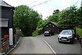
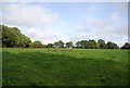
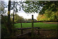
Magpie Bottom
Magpie Bottom is crossed by a footpath at Eastdown.
Image: © DS Pugh
Taken: 27 Jun 2024
0.04 miles
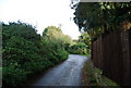
10
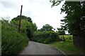
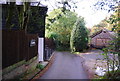
Magpie Bottom near Eastdown
The road is crossed by a footpath with the path heading south on the right.
Image: © DS Pugh
Taken: 27 Jun 2024
0.05 miles