IMAGES TAKEN NEAR TO
Row Dow Lane, SEVENOAKS, TN15 6XN
Introduction
This page details the photographs taken nearby to Row Dow Lane, TN15 6XN by members of the Geograph project.
The Geograph project started in 2005 with the aim of publishing, organising and preserving representative images for every square kilometre of Great Britain, Ireland and the Isle of Man.

There are currently over 7.5m images from over14,400 individuals and you can help contribute to the project by visiting https://www.geograph.org.uk
Image Map
Images are licensed for reuse under creativecommons.org/licenses/by-sa/2.0
Notes
- Clicking on the map will re-center to the selected point.
- The higher the marker number, the further away the image location is from the centre of the postcode.
Image Listing (15 Images Found)
Images are licensed for reuse under creativecommons.org/licenses/by-sa/2.0
Image
Details
Distance
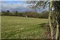
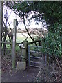
3
Public footpath near Otford
A gate leading to a public footpath near Otford, Kent.
Image: © Malc McDonald
Taken: 15 Jan 2012
0.16 miles
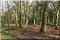
4
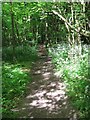
Footpath in Great Wood
Footpath No.SR30 leads through this wood from Rowdown Lane to Magpie Bottom Road, near Eastdown.
Image: © David Anstiss
Taken: 21 May 2009
0.17 miles
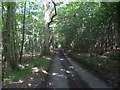
5
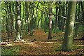
Autumn footpath, Great Wood
Mainly beech trees here.
Image: © Robin Webster
Taken: 24 Oct 2010
0.17 miles
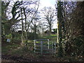
6
Public footpath near Otford
A sign for a public footpath near Otford, Kent.
Image: © Malc McDonald
Taken: 15 Jan 2012
0.18 miles
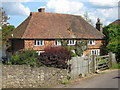
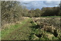
9
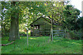
Old shed, Stursdon Farm
The footpath, running this side of the fence, is mapped as an ancient trackway.
Image: © Robin Webster
Taken: 24 Oct 2010
0.19 miles
10
Magpie Bottom
This is the road down to the collection of houses at Magpie Bottom. It is also called Magpie Bottom. This is a very wooded area. Doctor's Wood is to the left and Sandyburrow Wood is to the right.
Image: © Marathon
Taken: 4 Jul 2014
0.21 miles