IMAGES TAKEN NEAR TO
Highfield Road, SEVENOAKS, TN15 6TN
Introduction
This page details the photographs taken nearby to Highfield Road, TN15 6TN by members of the Geograph project.
The Geograph project started in 2005 with the aim of publishing, organising and preserving representative images for every square kilometre of Great Britain, Ireland and the Isle of Man.

There are currently over 7.5m images from over14,400 individuals and you can help contribute to the project by visiting https://www.geograph.org.uk
Image Map
Images are licensed for reuse under creativecommons.org/licenses/by-sa/2.0
Notes
- Clicking on the map will re-center to the selected point.
- The higher the marker number, the further away the image location is from the centre of the postcode.
Image Listing (43 Images Found)
Images are licensed for reuse under creativecommons.org/licenses/by-sa/2.0
Image
Details
Distance
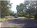
3
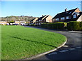
Barnfield Crescent, Kemsing
This green is towards the edge of Kemsing and is seen here from Collet Road. Barnfield Crescent forms the other three sides of the square.
Image: © Marathon
Taken: 24 Jan 2015
0.07 miles
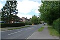
5
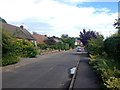
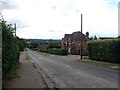
Childsbridge Lane near Bowden Court
Childsbridge Lane in Kemsing heading towards Seal.
Image: © DS Pugh
Taken: 27 Jun 2024
0.10 miles
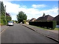
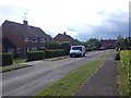
6
Childsbridge Lane near Collet Road
Childsbridge Lane in Kemsing.
Image: © DS Pugh
Taken: 27 Jun 2024
0.10 miles
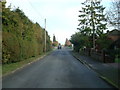
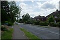
10
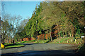
Pilgrims' Way, Kemsing
From the junction on the left with Childsbridge Lane the Pilgrim's Way widens out and becomes the northern edge of the Kemsing residential area.
Image: © Robin Webster
Taken: 12 Dec 2011
0.12 miles