IMAGES TAKEN NEAR TO
Pilgrims Way, SEVENOAKS, TN15 6TE
Introduction
This page details the photographs taken nearby to Pilgrims Way, TN15 6TE by members of the Geograph project.
The Geograph project started in 2005 with the aim of publishing, organising and preserving representative images for every square kilometre of Great Britain, Ireland and the Isle of Man.

There are currently over 7.5m images from over14,400 individuals and you can help contribute to the project by visiting https://www.geograph.org.uk
Image Map
Images are licensed for reuse under creativecommons.org/licenses/by-sa/2.0
Notes
- Clicking on the map will re-center to the selected point.
- The higher the marker number, the further away the image location is from the centre of the postcode.
Image Listing (28 Images Found)
Images are licensed for reuse under creativecommons.org/licenses/by-sa/2.0
Image
Details
Distance
1
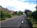
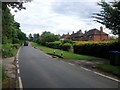
Pilgrims' Way, Kemsing
From the junction on the left with Childsbridge Lane the Pilgrim's Way widens out and becomes the northern edge of the Kemsing residential area.
Image: © Robin Webster
Taken: 12 Dec 2011
0.08 miles
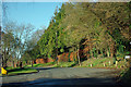
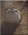
3
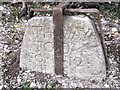
Way stone, Kemsing
Located N side of Pilgrims Way and Childsbridge Lane.
Directions to Dartford N, Malling E, Sevenoaks S, Bromley W
Image: © Steve Hover
Taken: 3 Apr 2021
0.09 miles
4
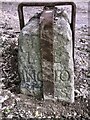
Waystone, Kemsing
Waystone. Located N of Pilgrims Way and Childsbridge Lane, Kemsing.
View facing East towards Malling
Image: © Steve Hover
Taken: 3 Apr 2021
0.09 miles
6
Old Guide Stone by Pilgrims Way, Kemsing parish
Stone post by the UC road, in parish of Kemsing (Sevenoaks District), Pilgrims Way, to West, and adjoining track to Kemsing Down Nature Reserve. Opposite junction with Childsbridge Lane, on the verge next to signpost and protected by an iron band. New stronger bands fitted before 2021.
Inscriptions read:-
North face: ‘the way to Dartford’
West face: ‘to Brom(le)y 12 miles’
East face: ‘to Malling 10 miles’
South face illegible but formerly read ‘the way to Sevenoaks’
Scheduled Monument.
List Entry Number: 1004215 https://historicengland.org.uk/listing/the-list/list-entry/1004215
Surveyed
Milestone Society National ID: KE_XKEM
Image: © Milestone Society
Taken: Unknown
0.10 miles
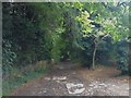
7
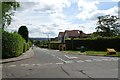
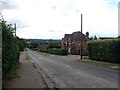
Junction of Childsbridge Lane and Pilgrims Way
The road ahead leads to Seal.
Image: © DS Pugh
Taken: 27 Jun 2024
0.10 miles