IMAGES TAKEN NEAR TO
Castle Drive, SEVENOAKS, TN15 6RN
Introduction
This page details the photographs taken nearby to Castle Drive, TN15 6RN by members of the Geograph project.
The Geograph project started in 2005 with the aim of publishing, organising and preserving representative images for every square kilometre of Great Britain, Ireland and the Isle of Man.

There are currently over 7.5m images from over14,400 individuals and you can help contribute to the project by visiting https://www.geograph.org.uk
Image Map
Images are licensed for reuse under creativecommons.org/licenses/by-sa/2.0
Notes
- Clicking on the map will re-center to the selected point.
- The higher the marker number, the further away the image location is from the centre of the postcode.
Image Listing (27 Images Found)
Images are licensed for reuse under creativecommons.org/licenses/by-sa/2.0
Image
Details
Distance
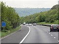
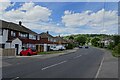
4
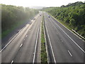
M26 Motorway heading to the M25
This motorway leads from Junction 2A for Wrotham, to the M25 (junction 5). As seen from Childbridge Lane roadbridge.
Image: © David Anstiss
Taken: 16 Aug 2009
0.15 miles
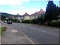
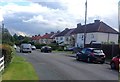
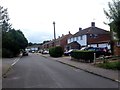
9
Houses on Childsbridge Lane
Looking towards Kemsing Down along Childsbridge Lane.
Image: © DS Pugh
Taken: 27 Jun 2024
0.17 miles