IMAGES TAKEN NEAR TO
West End, SEVENOAKS, TN15 6QE
Introduction
This page details the photographs taken nearby to West End, TN15 6QE by members of the Geograph project.
The Geograph project started in 2005 with the aim of publishing, organising and preserving representative images for every square kilometre of Great Britain, Ireland and the Isle of Man.

There are currently over 7.5m images from over14,400 individuals and you can help contribute to the project by visiting https://www.geograph.org.uk
Image Map
Images are licensed for reuse under creativecommons.org/licenses/by-sa/2.0
Notes
- Clicking on the map will re-center to the selected point.
- The higher the marker number, the further away the image location is from the centre of the postcode.
Image Listing (37 Images Found)
Images are licensed for reuse under creativecommons.org/licenses/by-sa/2.0
Image
Details
Distance
1
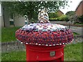
Pillar box with a hat
This is outside Kemsing Library on West End and is a close up of the top of the pillar box seen at https://www.geograph.org.uk/photo/6897961
Image: © Marathon
Taken: 11 Jul 2021
0.03 miles
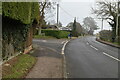
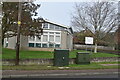
3
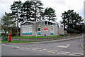
Kemsing Library
Just discernible on the red sign is the prancing horse of Kent.
Image: © Robin Webster
Taken: 28 Jan 2007
0.03 miles
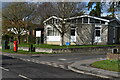
6
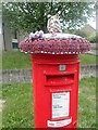
Pillar box with a hat
This is outside Kemsing Library on West End. A close up of the hat can be seen at https://www.geograph.org.uk/photo/6897969
Image: © Marathon
Taken: 11 Jul 2021
0.03 miles