IMAGES TAKEN NEAR TO
High Street, SEVENOAKS, TN15 6NB
Introduction
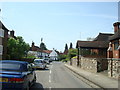
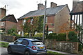
This page details the photographs taken nearby to High Street, TN15 6NB by members of the Geograph project.
The Geograph project started in 2005 with the aim of publishing, organising and preserving representative images for every square kilometre of Great Britain, Ireland and the Isle of Man.

There are currently over 7.5m images from over14,400 individuals and you can help contribute to the project by visiting https://www.geograph.org.uk
Image Map
Images are licensed for reuse under creativecommons.org/licenses/by-sa/2.0
Notes
- Clicking on the map will re-center to the selected point.
- The higher the marker number, the further away the image location is from the centre of the postcode.
Image Listing (130 Images Found)
Images are licensed for reuse under creativecommons.org/licenses/by-sa/2.0
Image
Details
Distance
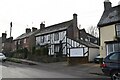
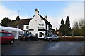
4
The Wheatsheaf, Kemsing, 2007
In competition with the Bell, over the road, it lost. It was demolished and the site is now houses.
Image: © Robin Webster
Taken: 28 Jan 2007
0.02 miles
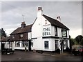
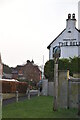
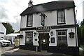
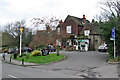
5

The Bell, Kemsing
To the right, the war memorial is in a little garden.
Image: © Humphrey Bolton
Taken: 13 Sep 2015
0.02 miles