IMAGES TAKEN NEAR TO
School Lane, SEVENOAKS, TN15 6JH
Introduction
This page details the photographs taken nearby to School Lane, TN15 6JH by members of the Geograph project.
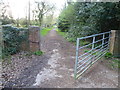
The Geograph project started in 2005 with the aim of publishing, organising and preserving representative images for every square kilometre of Great Britain, Ireland and the Isle of Man.

There are currently over 7.5m images from over14,400 individuals and you can help contribute to the project by visiting https://www.geograph.org.uk
Image Map
Images are licensed for reuse under creativecommons.org/licenses/by-sa/2.0
Notes
- Clicking on the map will re-center to the selected point.
- The higher the marker number, the further away the image location is from the centre of the postcode.
Image Listing (14 Images Found)
Images are licensed for reuse under creativecommons.org/licenses/by-sa/2.0
Image
Details
Distance
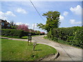
2
School Lane, West Kingsdown
A narrow lane broadens on entering a more built up area.
Image: © Robin Webster
Taken: 28 Jan 2007
0.08 miles
3
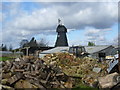
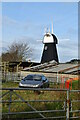
Windmill, Pell's Lane
Derelict windmill off Pell's Lane, West Kingsdown.
Image: © Brian Green
Taken: 22 Aug 2007
0.14 miles
4
Track leading to Stacklands Retreat
Seen from School Lane, this track, which is clearly little-used, leads to Stacklands Retreat. Although it has been derelict for many years - see http://www.geograph.org.uk/photo/1256362 - a planning application was submitted in 2013 for the demolition of the Retreat and construction of four detached houses.
Image: © Marathon
Taken: 8 Apr 2014
0.20 miles
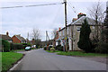
5
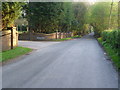
School Lane, West Kingsdown
This view along School Lane past Oakwood House (formerly Hollywood Cottage) is taken from the same place as http://www.geograph.org.uk/photo/3926026
Image: © Marathon
Taken: 8 Apr 2014
0.22 miles
6
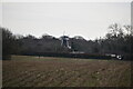
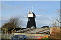
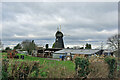
West Kingsdown Windmill
West Kingsdown Windmill is a smock mill and is seen here from Pells Lane looking across the farmyard of Mill Farm. West Kingsdown Windmill was built in the early 19th century at Chimham's Farm, Farningham, but in 1880, it was moved to West Kingsdown, joining a post mill that was already there. The post mill burnt down in May 1909. The smock mill was working by wind until 1928, but one of the sails was damaged on 25th December 1929 and the fantail blew off in November 1930. It is currently awaiting new sails.
Image: © Marathon
Taken: 5 Feb 2013
0.22 miles
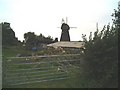
9
Kingsdown Windmill
A grade II listed building, 1800, but moved here from Farningham in 1880.
Image: © Robin Webster
Taken: 28 Jan 2007
0.22 miles