IMAGES TAKEN NEAR TO
Viking Way, SEVENOAKS, TN15 6DY
Introduction
This page details the photographs taken nearby to Viking Way, TN15 6DY by members of the Geograph project.
The Geograph project started in 2005 with the aim of publishing, organising and preserving representative images for every square kilometre of Great Britain, Ireland and the Isle of Man.

There are currently over 7.5m images from over14,400 individuals and you can help contribute to the project by visiting https://www.geograph.org.uk
Image Map
Images are licensed for reuse under creativecommons.org/licenses/by-sa/2.0
Notes
- Clicking on the map will re-center to the selected point.
- The higher the marker number, the further away the image location is from the centre of the postcode.
Image Listing (4 Images Found)
Images are licensed for reuse under creativecommons.org/licenses/by-sa/2.0
Image
Details
Distance
2
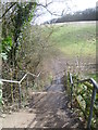
Steps at the end of Hever Road, West Kingsdown
Hever Road is the first road on the left, heading down the A20 away from Farningham when West Kingsdown is reached. This is at the far end where some steps descend to a footpath across the field and up the hill to reach Fawkham Road.
Image: © Marathon
Taken: 5 Feb 2013
0.20 miles
3
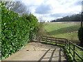
The end of Hever Road, West Kingsdown
Hever Road is the first road on the left, heading down the A20 away from Farningham when West Kingsdown is reached. This is at the far end where some steps descend to a footpath across the field and up the hill to reach Fawkham Road.
Image: © Marathon
Taken: 5 Feb 2013
0.22 miles
4
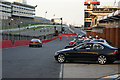
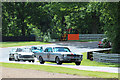
Brand's Hatch Pit Lane
Evening practice on a fine August evening. Brand's Hatch can be hired for private meetings and on this occasion, a group of London Air Traffic Controllers took their own cars along to try them on the race circuit. Surprisingly, all survived.
Image: © Brendan and Ruth McCartney
Taken: 15 Aug 2005
0.22 miles