IMAGES TAKEN NEAR TO
Botsom Lane, SEVENOAKS, TN15 6BN
Introduction
This page details the photographs taken nearby to Botsom Lane, TN15 6BN by members of the Geograph project.
The Geograph project started in 2005 with the aim of publishing, organising and preserving representative images for every square kilometre of Great Britain, Ireland and the Isle of Man.

There are currently over 7.5m images from over14,400 individuals and you can help contribute to the project by visiting https://www.geograph.org.uk
Image Map
Images are licensed for reuse under creativecommons.org/licenses/by-sa/2.0
Notes
- Clicking on the map will re-center to the selected point.
- The higher the marker number, the further away the image location is from the centre of the postcode.
Image Listing (6 Images Found)
Images are licensed for reuse under creativecommons.org/licenses/by-sa/2.0
Image
Details
Distance
1
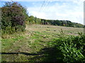
Looking up the side of Knatts Valley
This view is from the bottom of Botsom Lane which runs up the hillside on the left to reach West Kingsdown. Knatts Valley stretches away to the right. Considering West Kingsdown and the A20 are just up the top of the valley this countryside feels incredibly remote.
Image: © Marathon
Taken: 17 Oct 2012
0.17 miles

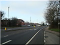
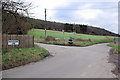
4
Knatts Valley Road, junction with Botsom Lane
Image: © Stacey Harris
Taken: 13 Feb 2010
0.24 miles
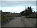
5
The start of Knatts Valley
This view is from the bottom of Botsom Lane which runs up the hillside on the left to reach West Kingsdown. Knatts Valley Road stretches away ahead along Knatts Valley. Considering West Kingsdown and the A20 are just up the top of the valley to the left this countryside feels incredibly remote.
Image: © Marathon
Taken: 17 Oct 2012
0.24 miles
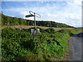
6
A Chalk Valley Lane Junction
Maplescombe Lane continues as Knatts Valley Road along the bottom of the valley, a position more normally occupied by a stream off the chalk. Botsom Lane turns off to climb steeply out of the valley up to the A20.
Image: © Robin Webster
Taken: 28 Jan 2007
0.25 miles