IMAGES TAKEN NEAR TO
Carter Avenue, London Road, SEVENOAKS, TN15 6BH
Introduction
This page details the photographs taken nearby to Carter Avenue, London Road, TN15 6BH by members of the Geograph project.
The Geograph project started in 2005 with the aim of publishing, organising and preserving representative images for every square kilometre of Great Britain, Ireland and the Isle of Man.

There are currently over 7.5m images from over14,400 individuals and you can help contribute to the project by visiting https://www.geograph.org.uk
Image Map
Images are licensed for reuse under creativecommons.org/licenses/by-sa/2.0
Notes
- Clicking on the map will re-center to the selected point.
- The higher the marker number, the further away the image location is from the centre of the postcode.
Image Listing (8 Images Found)
Images are licensed for reuse under creativecommons.org/licenses/by-sa/2.0
Image
Details
Distance
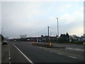
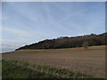
2
A20, West Kingsdown
Formerly busy in pre-M20 days, now less so except when Brands Hatch is on the go.
Image: © Robin Webster
Taken: 28 Jan 2007
0.12 miles
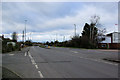
5
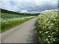
Cow parsley in Knatts Valley
There are a number of places along the narrow Knatts Valley Road where it is possible to stop. After the junction with Botsom Lane, there is a surprisingly long stretch southwards along Knatts Valley Road before a house is reached and it feels incredibly remote and yet beyond the steep wooded slope on the left is the sprawl of West Kingsdown.
Image: © Marathon
Taken: 27 May 2019
0.24 miles

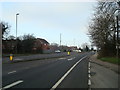
8
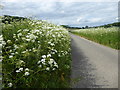
Cow parsley in Knatts Valley
There are a number of places along the narrow Knatts Valley Road where it is possible to stop. After the junction with Botsom Lane, there is a surprisingly long stretch southwards along Knatts Valley Road before a house is reached and it feels incredibly remote and yet beyond the steep wooded slope on the right is the sprawl of West Kingsdown. See https://www.geograph.org.uk/photo/6180498 for the view in the other direction.
Image: © Marathon
Taken: 27 May 2019
0.25 miles