IMAGES TAKEN NEAR TO
Pells Lane, SEVENOAKS, TN15 6AU
Introduction
This page details the photographs taken nearby to Pells Lane, TN15 6AU by members of the Geograph project.
The Geograph project started in 2005 with the aim of publishing, organising and preserving representative images for every square kilometre of Great Britain, Ireland and the Isle of Man.

There are currently over 7.5m images from over14,400 individuals and you can help contribute to the project by visiting https://www.geograph.org.uk
Image Map
Images are licensed for reuse under creativecommons.org/licenses/by-sa/2.0
Notes
- Clicking on the map will re-center to the selected point.
- The higher the marker number, the further away the image location is from the centre of the postcode.
Image Listing (29 Images Found)
Images are licensed for reuse under creativecommons.org/licenses/by-sa/2.0
Image
Details
Distance
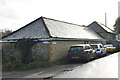
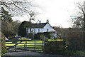
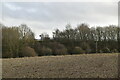
2
Pells Farm on Pells Lane
Just some of the farm buildings are seen.
Image: © Robin Webster
Taken: 28 Jan 2007
0.04 miles
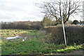
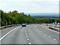
9
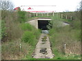
Footpath under M20 Motorway
The path from Pells Lane, near Pell Farm leads under the railway to lead past Peckham Wood to Terry's Lodge Road. The M20 Motorway heads left up hill to Junction 3 on the M25 Orbital Motorway, from Junction 2 Wrotham.
Image: © David Anstiss
Taken: 15 Apr 2009
0.16 miles