IMAGES TAKEN NEAR TO
Underriver, SEVENOAKS, TN15 0SL
Introduction
This page details the photographs taken nearby to TN15 0SL by members of the Geograph project.
The Geograph project started in 2005 with the aim of publishing, organising and preserving representative images for every square kilometre of Great Britain, Ireland and the Isle of Man.

There are currently over 7.5m images from over14,400 individuals and you can help contribute to the project by visiting https://www.geograph.org.uk
Image Map
Images are licensed for reuse under creativecommons.org/licenses/by-sa/2.0
Notes
- Clicking on the map will re-center to the selected point.
- The higher the marker number, the further away the image location is from the centre of the postcode.
Image Listing (53 Images Found)
Images are licensed for reuse under creativecommons.org/licenses/by-sa/2.0
Image
Details
Distance
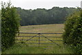
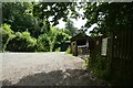
2

Path and fence near White Rocks
The footpath runs between Knowle and Ightham Mote.
Image: © DS Pugh
Taken: 6 Jul 2023
0.13 miles
3

Path near White Rocks
The footpath runs between Knowle and Ightham Mote.
Image: © DS Pugh
Taken: 6 Jul 2023
0.14 miles
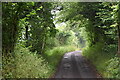
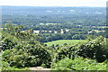
6
Track onto the Greensand Ridge
Out of breath after climbing up this wonderful hollowed track onto the Greensand Ridge. It is located between Rooks Hill and One Tree Hill
Image: © Chris Heaton
Taken: 19 Apr 1995
0.15 miles
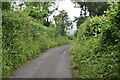
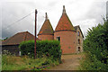
7
White Rocks Farm
The farm entrance viewed from a footpath between Knowle and Ightham Mote.
Image: © DS Pugh
Taken: 6 Jul 2023
0.16 miles
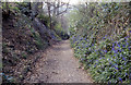
10
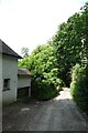
Path at White Rocks
The footpath between Knowle and Ightham Mote passing the farm cottage.
Image: © DS Pugh
Taken: 6 Jul 2023
0.18 miles