IMAGES TAKEN NEAR TO
Dux Hill, SEVENOAKS, TN15 0RD
Introduction
This page details the photographs taken nearby to Dux Hill, TN15 0RD by members of the Geograph project.
The Geograph project started in 2005 with the aim of publishing, organising and preserving representative images for every square kilometre of Great Britain, Ireland and the Isle of Man.

There are currently over 7.5m images from over14,400 individuals and you can help contribute to the project by visiting https://www.geograph.org.uk
Image Map
Images are licensed for reuse under creativecommons.org/licenses/by-sa/2.0
Notes
- Clicking on the map will re-center to the selected point.
- The higher the marker number, the further away the image location is from the centre of the postcode.
Image Listing (15 Images Found)
Images are licensed for reuse under creativecommons.org/licenses/by-sa/2.0
Image
Details
Distance
4
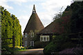
Oast Cottage, Grange Hill, Plaxtol, Kent
Image: © Oast House Archive
Taken: 5 Apr 2009
0.17 miles
5

Barn of Grange Oast
This large (Norman-style) barn is on Grange Hill.
Image: © David Anstiss
Taken: 6 May 2009
0.17 miles
6
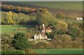
Grange Hill at The Grange, Plaxtol
The Grange is listed, Grade II*, and the listing details include: "House. Early C17 house refronted in 1702, remodelled in 1926 by Sir Edwin Lutyens." The 18C wall and gate piers are also listed, Grade II.
Image: © Humphrey Bolton
Taken: 12 Sep 2015
0.20 miles