IMAGES TAKEN NEAR TO
Dux Lane, SEVENOAKS, TN15 0QY
Introduction
This page details the photographs taken nearby to Dux Lane, TN15 0QY by members of the Geograph project.
The Geograph project started in 2005 with the aim of publishing, organising and preserving representative images for every square kilometre of Great Britain, Ireland and the Isle of Man.

There are currently over 7.5m images from over14,400 individuals and you can help contribute to the project by visiting https://www.geograph.org.uk
Image Map
Images are licensed for reuse under creativecommons.org/licenses/by-sa/2.0
Notes
- Clicking on the map will re-center to the selected point.
- The higher the marker number, the further away the image location is from the centre of the postcode.
Image Listing (35 Images Found)
Images are licensed for reuse under creativecommons.org/licenses/by-sa/2.0
Image
Details
Distance
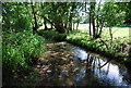

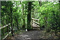
6

Footbridge over River Bourne
On footpath from Old Soar Road, to Long Mill Lane. Woods either side of river covered in wild garlic.
Image: © David Anstiss
Taken: 6 May 2009
0.17 miles
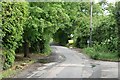
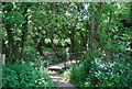
10

Pipe Footbridge
These concrete pipes were laid in a stream to allow walkers to go on path from Brook Lane to Dux Lane.
Image: © David Anstiss
Taken: 6 May 2009
0.19 miles