IMAGES TAKEN NEAR TO
School Lane, SEVENOAKS, TN15 0QD
Introduction
This page details the photographs taken nearby to School Lane, TN15 0QD by members of the Geograph project.
The Geograph project started in 2005 with the aim of publishing, organising and preserving representative images for every square kilometre of Great Britain, Ireland and the Isle of Man.

There are currently over 7.5m images from over14,400 individuals and you can help contribute to the project by visiting https://www.geograph.org.uk
Image Map
Images are licensed for reuse under creativecommons.org/licenses/by-sa/2.0
Notes
- Clicking on the map will re-center to the selected point.
- The higher the marker number, the further away the image location is from the centre of the postcode.
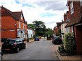
Image Listing (192 Images Found)
Images are licensed for reuse under creativecommons.org/licenses/by-sa/2.0
Image
Details
Distance
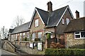
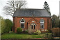
1

Converted Wesleyan Chapel
House on School Lane, opposite Plaxtol Primary School. Dated 1895
Image: © David Anstiss
Taken: 6 May 2009
0.01 miles
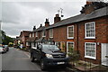
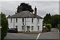
6
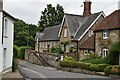
Old School Cottage
Grade II listed, https://historicengland.org.uk/listing/the-list/list-entry/1204746
Image: © N Chadwick
Taken: 19 Jun 2020
0.04 miles