IMAGES TAKEN NEAR TO
Ismays Road, SEVENOAKS, TN15 0NZ
Introduction
This page details the photographs taken nearby to Ismays Road, TN15 0NZ by members of the Geograph project.
The Geograph project started in 2005 with the aim of publishing, organising and preserving representative images for every square kilometre of Great Britain, Ireland and the Isle of Man.

There are currently over 7.5m images from over14,400 individuals and you can help contribute to the project by visiting https://www.geograph.org.uk
Image Map
Images are licensed for reuse under creativecommons.org/licenses/by-sa/2.0
Notes
- Clicking on the map will re-center to the selected point.
- The higher the marker number, the further away the image location is from the centre of the postcode.
Image Listing (58 Images Found)
Images are licensed for reuse under creativecommons.org/licenses/by-sa/2.0
Image
Details
Distance
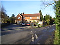
6
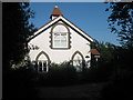
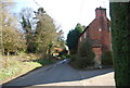
Old Church House
Converted Church on Coach Road in Ivyhatch.
Image: © David Anstiss
Taken: 24 May 2009
0.09 miles
8
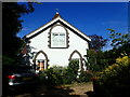
Old Church House
This former chapel on Coach Road at Ivy Hatch has been converted into a private house.
Image: © Marathon
Taken: 9 Jul 2022
0.10 miles

10
The Plough at Ivy Hatch
The road to the left goes to Ightham Common or Stone Street and the one to the right goes to the village of Ightham. To keep The Plough company, in Ightham Common, just up the road, can be found The Harrow Inn - see http://www.geograph.org.uk/photo/4324749
Image: © Marathon
Taken: 24 Jan 2015
0.10 miles