IMAGES TAKEN NEAR TO
Church Road, Stone Street, SEVENOAKS, TN15 0LL
Introduction
This page details the photographs taken nearby to Church Road, Stone Street, TN15 0LL by members of the Geograph project.
The Geograph project started in 2005 with the aim of publishing, organising and preserving representative images for every square kilometre of Great Britain, Ireland and the Isle of Man.

There are currently over 7.5m images from over14,400 individuals and you can help contribute to the project by visiting https://www.geograph.org.uk
Image Map
Images are licensed for reuse under creativecommons.org/licenses/by-sa/2.0
Notes
- Clicking on the map will re-center to the selected point.
- The higher the marker number, the further away the image location is from the centre of the postcode.
Image Listing (92 Images Found)
Images are licensed for reuse under creativecommons.org/licenses/by-sa/2.0
Image
Details
Distance
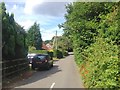
2
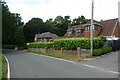
Houses on Stone Street Road
Looking towards some houses in the village.
Image: © DS Pugh
Taken: 6 Jul 2023
0.08 miles
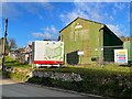
4
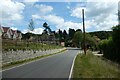
New houses in Stone Street
New houses on the left are under construction on the site of Foxbury Farm.
Image: © DS Pugh
Taken: 6 Jul 2023
0.08 miles
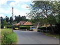
5
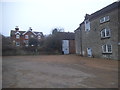
The entrance to Foxbury Farm, Stone Street
Image: © David Howard
Taken: 18 Dec 2016
0.09 miles
7
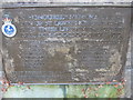
Plaque on War Memorial, Seal
On Church Road.
Image: © David Anstiss
Taken: 24 May 2009
0.09 miles