IMAGES TAKEN NEAR TO
Godden Green, SEVENOAKS, TN15 0JU
Introduction
This page details the photographs taken nearby to TN15 0JU by members of the Geograph project.
The Geograph project started in 2005 with the aim of publishing, organising and preserving representative images for every square kilometre of Great Britain, Ireland and the Isle of Man.

There are currently over 7.5m images from over14,400 individuals and you can help contribute to the project by visiting https://www.geograph.org.uk
Image Map
Images are licensed for reuse under creativecommons.org/licenses/by-sa/2.0
Notes
- Clicking on the map will re-center to the selected point.
- The higher the marker number, the further away the image location is from the centre of the postcode.
Image Listing (13 Images Found)
Images are licensed for reuse under creativecommons.org/licenses/by-sa/2.0
Image
Details
Distance
1
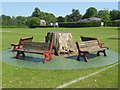
Tree Stump and Benches
In playing field of Sevenoaks Preparatory School. A footpath leads through the field to Knole Park.
Image: © David Anstiss
Taken: 24 May 2009
0.05 miles
2
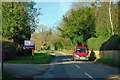
Sevenoaks Preparatory School main entrance
The mail van is about to pay the school a visit.
Image: © Robin Webster
Taken: 6 Jan 2012
0.05 miles
3
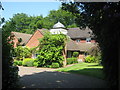
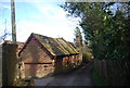
Little Steading
On access road from Park Lane. Has unusual little tower.
Image: © David Anstiss
Taken: 24 May 2009
0.11 miles
5
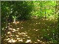
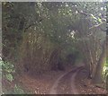
Footpath junction in Lord's Spring Wood
Path from Park Lane leads straight on through wood to bridleway to Great Roger's Wood. Another path crosses right to Fawke Farm from Park Lane, Godden Green.
Image: © David Anstiss
Taken: 24 May 2009
0.20 miles