IMAGES TAKEN NEAR TO
Back Lane, SEVENOAKS, TN15 0JG
Introduction
This page details the photographs taken nearby to Back Lane, TN15 0JG by members of the Geograph project.
The Geograph project started in 2005 with the aim of publishing, organising and preserving representative images for every square kilometre of Great Britain, Ireland and the Isle of Man.

There are currently over 7.5m images from over14,400 individuals and you can help contribute to the project by visiting https://www.geograph.org.uk
Image Map
Images are licensed for reuse under creativecommons.org/licenses/by-sa/2.0
Notes
- Clicking on the map will re-center to the selected point.
- The higher the marker number, the further away the image location is from the centre of the postcode.
Image Listing (80 Images Found)
Images are licensed for reuse under creativecommons.org/licenses/by-sa/2.0
Image
Details
Distance
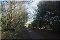
5

Footpath to Sevenoaks
This path through Godden Wood from Godden Green to Knole and Sevenoaks is only shown as public footpath status on the map, but in fact is used as a bridleway (though the kissing gate at the edge of Knole Park would not be passable with a horse).
Image: © Stephen Craven
Taken: 11 Oct 2008
0.04 miles
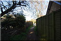
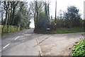
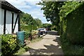
7
Path between Park Lane and Back Lane
Footpath SR167 in Godden Green.
Image: © DS Pugh
Taken: 6 Jul 2023
0.05 miles
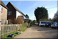
9
Path to Park Lane
This footpath connects Back Lane and Park Lane in Godden Green.
Image: © DS Pugh
Taken: 6 Jul 2023
0.06 miles