IMAGES TAKEN NEAR TO
Meadowlands, SEVENOAKS, TN15 0DH
Introduction
This page details the photographs taken nearby to Meadowlands, TN15 0DH by members of the Geograph project.
The Geograph project started in 2005 with the aim of publishing, organising and preserving representative images for every square kilometre of Great Britain, Ireland and the Isle of Man.

There are currently over 7.5m images from over14,400 individuals and you can help contribute to the project by visiting https://www.geograph.org.uk
Image Map
Images are licensed for reuse under creativecommons.org/licenses/by-sa/2.0
Notes
- Clicking on the map will re-center to the selected point.
- The higher the marker number, the further away the image location is from the centre of the postcode.
Image Listing (53 Images Found)
Images are licensed for reuse under creativecommons.org/licenses/by-sa/2.0
Image
Details
Distance
2
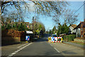
Road works on Childsbridge Lane
Refreshingly no lights on this short obstruction.
Image: © Robin Webster
Taken: 6 Jan 2012
0.06 miles
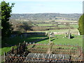
7
View from the churchyard of St Peter's Church, Seal
Pevsner says that "the fine west tower was under construction c.1520-9." The earliest parts of the church date from the 13th century. There are some fine tombs in the churchyard.
At the north end of the churchyard, this footpath heads across the fields to cross the railway and then the M26, before reaching Kemsing. As can be seen, there are fine views towards Kemsing and the scarp slope of the North Downs beyond.
Image: © Marathon
Taken: 24 Jan 2015
0.12 miles
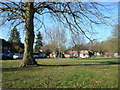
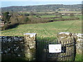
8
The churchyard of St Peter's Church, Seal
Pevsner says that "the fine west tower was under construction c.1520-9." The earliest parts of the church date from the 13th century. There are some fine tombs in the churchyard.
At the north end of the churchyard, a footpath heads out of the gate ahead to cross the fields, and then the railway and the M26, before reaching Kemsing. As can be seen, there are fine views towards Kemsing and the scarp slope of the North Downs beyond.
Image: © Marathon
Taken: 24 Jan 2015
0.13 miles