IMAGES TAKEN NEAR TO
High Street, SEVENOAKS, TN15 0AD
Introduction
This page details the photographs taken nearby to High Street, TN15 0AD by members of the Geograph project.
The Geograph project started in 2005 with the aim of publishing, organising and preserving representative images for every square kilometre of Great Britain, Ireland and the Isle of Man.

There are currently over 7.5m images from over14,400 individuals and you can help contribute to the project by visiting https://www.geograph.org.uk
Image Map
Images are licensed for reuse under creativecommons.org/licenses/by-sa/2.0
Notes
- Clicking on the map will re-center to the selected point.
- The higher the marker number, the further away the image location is from the centre of the postcode.
Image Listing (18 Images Found)
Images are licensed for reuse under creativecommons.org/licenses/by-sa/2.0
Image
Details
Distance
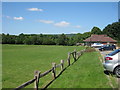
1
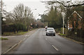
Junction of Seal Road and Ash Platt Road
Towards Seal.
Image: © J.Hannan-Briggs
Taken: 26 Dec 2014
0.02 miles
2
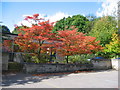
Seal Church of England Primary School in Autumn
Seal school is a small flat roofed school with at present 99 children
Image: © Jean Barrow
Taken: 6 Oct 2004
0.13 miles
4
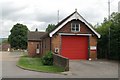
Seal fire station
Seal fire station, High Street, Seal, Kent
Image: © Kevin Hale
Taken: 17 Jun 2007
0.19 miles
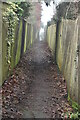
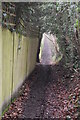
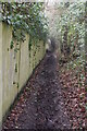
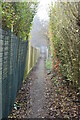
7
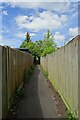
Path near Pinehurst
Connecting Childsbridge Lane and Seal Road.
Image: © DS Pugh
Taken: 27 Jun 2024
0.20 miles