IMAGES TAKEN NEAR TO
Cockerhurst Road, SEVENOAKS, TN14 7UA
Introduction
This page details the photographs taken nearby to Cockerhurst Road, TN14 7UA by members of the Geograph project.
The Geograph project started in 2005 with the aim of publishing, organising and preserving representative images for every square kilometre of Great Britain, Ireland and the Isle of Man.

There are currently over 7.5m images from over14,400 individuals and you can help contribute to the project by visiting https://www.geograph.org.uk
Image Map
Images are licensed for reuse under creativecommons.org/licenses/by-sa/2.0
Notes
- Clicking on the map will re-center to the selected point.
- The higher the marker number, the further away the image location is from the centre of the postcode.
Image Listing (13 Images Found)
Images are licensed for reuse under creativecommons.org/licenses/by-sa/2.0
Image
Details
Distance
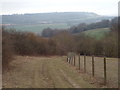
1
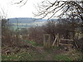
Stile near Shoreham
A stile and dog gate on a footpath in Kent countryside, near Shoreham. The dog gate served no purpose as the surrounding fence is missing.
Image: © Malc McDonald
Taken: 24 Mar 2018
0.05 miles
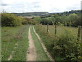
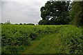
2
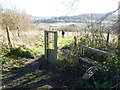
Footpath to Cockerhurst Road
This delightful footpath on the chalk leads steeply down to Cockerhurst Road on the western edge of the Darent Valley. The dog stile is in better condition than the stile.
Image: © Marathon
Taken: 21 Feb 2014
0.06 miles
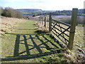
3
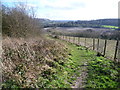
Footpath to Cockerhurst Road
This delightful footpath on the chalk leads steeply down to Cockerhurst Road on the western edge of the Darent Valley.
Image: © Marathon
Taken: 21 Feb 2014
0.07 miles
4
Footpath near Shoreham
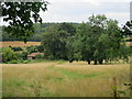
A public footpath near Shoreham, in the Kent countryside. The hills in this image form part of the North Downs ridge.
Image: © Malc McDonald
Taken: 24 Mar 2018
0.12 miles
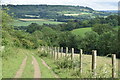
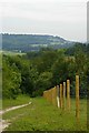
5
Footpath to Cockerhurst Road
This delightful footpath on the chalk leads steeply down to Cockerhurst Road on the western edge of the Darent Valley. The North Downs Way passes through the woods in the distance above Otford.
Image: © Marathon
Taken: 21 Feb 2014
0.13 miles
6
Footpath to Cockerhurst Road
This delightful footpath on the chalk leads steeply down to Cockerhurst Road on the western edge of the Darent Valley. The North Downs Way passes through the woods in the distance above Otford.
Image: © Marathon
Taken: 19 Sep 2022
0.14 miles
7
Path downhill to Cockerhurst Road
With a distant view across the Darent Valley.
Image: © David Martin
Taken: 3 Jul 2021
0.15 miles
8
Footpath Near Beechen Wood
This footpath runs from the gate of Lullingstone Golf Course to Redmans Lane. At this point on the edge of Beechen Wood it passes through a fern forest.
Image: © Glyn Baker
Taken: 25 Jun 2006
0.16 miles
9
View Across the Darenth Valley
This is the footpath from Redmans Lane to Cockerhurst Road looking towards Shoreham
Image: © Glyn Baker
Taken: 25 Jun 2006
0.16 miles