IMAGES TAKEN NEAR TO
Shacklands Road, SEVENOAKS, TN14 7TX
Introduction
This page details the photographs taken nearby to Shacklands Road, TN14 7TX by members of the Geograph project.
The Geograph project started in 2005 with the aim of publishing, organising and preserving representative images for every square kilometre of Great Britain, Ireland and the Isle of Man.

There are currently over 7.5m images from over14,400 individuals and you can help contribute to the project by visiting https://www.geograph.org.uk
Image Map (Loading...)


Getting Data...Please wait
Leaflet Map data © OpenStreetMap
Images are licensed for reuse under creativecommons.org/licenses/by-sa/2.0
Notes
- Clicking on the map will re-center to the selected point.
- The higher the marker number, the further away the image location is from the centre of the postcode.
Image Listing (18 Images Found)
Images are licensed for reuse under creativecommons.org/licenses/by-sa/2.0
Image
Details
Distance
1
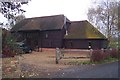
Hungrydown Barn
On Shacklands Road. The converted barn is near Timberden Farm.
Image: © David Anstiss
Taken: 8 Nov 2009
0.00 miles
2
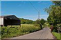
Timberden Farm
Outbuildings of this farm on Shacklands Road.
Image: © Ian Capper
Taken: 13 Jun 2012
0.02 miles
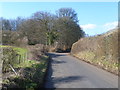
3
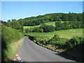
Shacklands Road
Towards Timberton Bottom, from junction of Chelsfield Lane.
Image: © Oast House Archive
Taken: 16 Jun 2010
0.07 miles
4
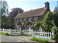
Timberden Farm Cottage
On Shacklands Road in Timbernden Bottom.
Image: © David Anstiss
Taken: 30 May 2009
0.07 miles
5
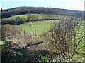
Countryside near Timberden Farm
This view looks from Shacklands Road by Timberden Farm up to Meenfield Wood on the ridge. Shoreham in the Darent Valley is on the far side.
Image: © Marathon
Taken: 17 Feb 2013
0.08 miles
6
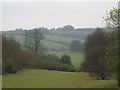
View from Meenfield Wood
Emerging from Meenfield Wood towards Timberden Bottom, the pasture studded with white daisies.
Image: © Trevor Harris
Taken: 2 Jun 2011
0.09 miles
7
Timberden Bottom
Shoreham Woods looking towards Timberden Bottom, Cottages and Farm buildings.
Image: © Daniel Woodward
Taken: 28 Apr 2012
0.10 miles
8
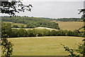
Field edge at Timberden Farm
This is the gently undulating countryside between Shoreham in the Darent Valley and Badger's Mount. The view is from Shacklands Road and Timberden Farmhouse is just to the right.
Image: © Marathon
Taken: 17 Feb 2013
0.11 miles
9
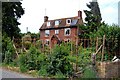
Timberden Farm
There should be a good crop of beans in the front garden later in the year.
Image: © Trevor Harris
Taken: 2 Jun 2011
0.11 miles
10
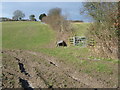
Shacklands Road near Timberden Farm
This is the gently undulating countryside between Shoreham in the Darent Valley and Badger's Mount. The view looks along Shacklands Road just past Timberden Farm. At the junction ahead Chelsfield Lane leads off to the right. Barnett's Wood can be seen beyond the junction. Both Shacklands Road and Chelsfield Lane cross the M25 just ahead.
Image: © Marathon
Taken: 17 Feb 2013
0.14 miles